
| Home |
| About ElarmS |
| Application? - tell us |
| California |
| South Korea |
| Turkey |
| Methodology |
| Research Highlights |
| Technical Publications |
| Press Highlights |
| Contact us |
| Acknowledgements |
ElarmS Methodology
Richard M Allen, University of California Berkeley.
Download a pdf of this ElarmS methodology summary
(0.4Mb pdf)
The ElarmS methodology was designed with the goal of predicting the distribution of peak ground shaking across the region affected by an earthquake before the beginning of significant ground motion at the epicenter. The first few seconds of the P-wave at the station and stations closest to the epicenter is used to estimate the magnitude of the earthquake and attenuation relations provide the predicted distribution of ground shaking as a function of distance from the epicenter [Allen, 2004]. Offline testing (described below) suggests that the methodology could provide warning before significant shaking has reached more than a few kilometers from the epicenter for all earthquakes in California, and could provide warning at the epicenter for some events depending on the proximity of seismic stations and the depth of the hypocenter. The use of single stations methodologies can provide warnings at the epicenter in scenarios where ElarmS cannot.
The complete ElarmS system is designed to generate a map of predicted peak ground shaking, a predicted-ShakeMap that we call "AlertMap". The first AlertMap is available 1 sec after the first P-wave trigger and is updated every second as additional data is gathered from stations further from the epicenter. Below we describe the three components of ElarmS.
Earthquake location and warning time estimation
Earthquakes are located using the arrival times of P-waves. When the first station triggers an event is located at that station with a depth typical of events in the region. The earthquake is then located between the first two, and then the first three stations to trigger. Once four stations have triggered a grid search method is used to locate the event minimizing the misfit between predicted and observed arrival times.
The warning time is defined as the remaining time until the onset of peak ground shaking and can be estimated given the origin time and location of the earthquake using S-wave arrival time curves. The use of the predicted S-arrival time provides a conservative estimate of the remaining warning time. In larger magnitude earthquakes, such as Northridge and Loma Prieta, peak ground shaking occurred 5-10 sec after the S-arrival at stations tens of kilometers from the epicenter.
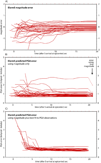
Offline testing of ElarmS using a dataset of 32 earthquakes in southern California shows that the first predictions of ground shaking are available before the S-arrival at the epicenter for 56% of earthquakes (Fig. 1a). The majority of these predictions are based on trigger times and magnitude estimates from more than one seismic station. The offline algorithms gather all available information and update hazard estimates once per second. The density of seismic stations (typically 20 km spacing in the populated regions) means that within a 1 sec time interval usually two, and often three, stations trigger. The first event location, hazard and warning time estimates are therefore based on information from multiply stations providing a more accurate location and magnitude estimate that using a single station (see next section).
|
Fig. 1. The results of testing ElarmS offline using a set of 32 earthquakes in southern California designed to test the accuracy and timeliness of warning information given the current distribution of stations. All panels show errors as a function of time with respect to the S-wave arrival at the epicenter which represents the earliest time of peak ground shaking during and earthquake. A) The error in the magnitude estimate. B) Average absolute error in PGA estimates at all stations using available magnitude and location estimates and the ElarmS attenuation relations. C) Average error in PGA once available PGA observations are incorporated. The error in the PGA estimates is calculated in the usual way: the error is the natural logarithm of the predicted PGA minus the natural logarithm of the observed PGA for the event. |
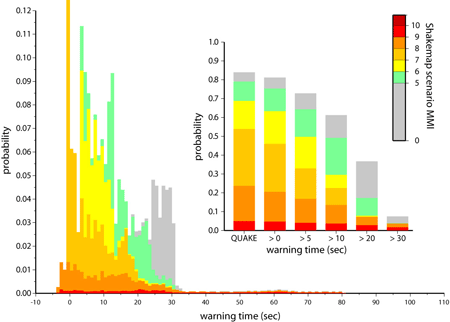
Warning time probability density functions using the ElarmS methodology have been calculated for northern California. These are based on the current distribution of broadband velocity and accelerometer stations across the region and the 35 earthquake rupture scenarios identified by the Working Group on California Earthquake Probabilities [2003]. Fig. 2 shows the probability that there will be an earthquake in the next 30 years for which there would be a given warning time for the city of San Francisco. The warning times for different events range between -4 sec (i.e. the warning would only be available 4 sec after peak ground shaking had started) and 80 sec. The color scale indicates the predicted intensity of ground shaking for the city for each event using the Scenario ShakeMaps. The inset to Fig. 2 shows the probability there will be greater than 0, 5, 10, 20 and 30 sec of warning along with the cumulative probability of one of the 35 rupture scenarios occurring (labeled QUAKE). These calculations show that it would be possible to provide warning for the vast majority of these damaging earthquakes. It also shows that for the most damaging events that cause ground shaking with MMI > X in the city, it is more likely than not that there will be more than 20 sec warning.
|
|
Fig. 2. Earthquake early warning time probability density function for the city of San Francisco. Warning times were calculated for the 35 rupture scenarios identified by the Working Group on California Earthquake Probabilities [2003] and the probability of each rupture assigned to the warning time. Epicenters were distributed at 1 km intervals along the complete length of each rupture and the cumulative probability of all events set equal to the probability of the rupture scenario. The warning time is defined as the time at which 4 sec of the P-wave is available at 2 stations and a 2 sec delay for telemetry has been added. This distribution of warning times is based on the current distribution of stations with a moderate improvement to telemetry. The warning times are color coded by the predicted intensity of ground shaking in the city using the scenario ShakeMaps. The inset shows the probability of greater than 0, 5, 10, 20 and 30 sec warning along with the total probability of all 35 rupture scenarios (labeled QUAKE). |
Rapid earthquake magnitude estimation
The magnitude of an earthquake is rapidly estimated using the frequency content of the first four seconds of the P-wave arrival. The predominant period, tau-p , of the vertical component waveform is calculated using the method first described by Nakamura [1988]. Before calculation of tau-p, accelerometer recordings are converted to velocity and all waveforms are low-pass filtered with a corner at 3 Hz. All processing is done recursively in a causal fashion. The maximum value of the tau-p timeseries within 4 sec of the P-wave arrival, tau-p-max, is found to scale with the magnitude of earthquakes.
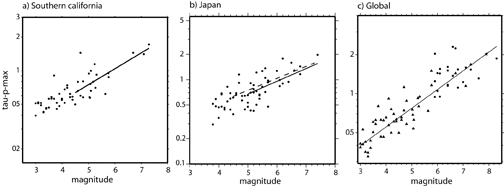
Tau-p-max has been calculated for earthquakes with magnitudes ranging from 3.0 to 8.3 from various regions around the world. Fig. 3 shows the scaling relation for waveform datasets from southern California [Allen and Kanamori, 2003], Japan [Lockman and Allen, in review], and a global dataset including waveforms from southern California, Japan, Taiwan and the Denali earthquake in Alaska [Olson and Allen, in review]. The data shows no evidence to suggest that the scaling relation breaks down for the largest magnitude events with rupture durations greater than 4 sec. Instead, all the data available suggest that the magnitude of an earthquake is to some degree determined within the first few seconds of rupture [Olson and Allen, in review]. There is a range of tau-p-max values for a given magnitude event, i.e. an uncertainty in the magnitude estimate derived from tau-p-max observations, which could be due to rupture processes or station site effects.
|
|
Fig. 3. Scaling relation between event-averaged tau-p-max and magnitude. All data has been processed using the same recursive algorithms. A) Southern California earthquakes and best fit relation (solid line). From [Allen and Kanamori, 2003]. B) Earthquakes in Japan and best fit relation (solid line). The dashed line is the best fit relation for California shown in A which is nearly identical. From [Lockman and Allen, in review]. C) Global compilation of earthquakes including southern California, Japan, Taiwan and the Denali earthquake. Waveforms are a mixture of accelerometers and broadband velocity instruments. From [Olson and Allen, in review]. |
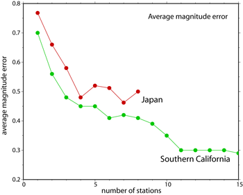
The accuracy and timeliness of magnitude estimates are central to the usefulness of an early warning system. The accuracy of magnitude estimates are a function of the number stations providing P-wave data. Fig. 4 shows how the average error of magnitude estimates decrease as tau-p-max observations at multiple stations are combined to provide an average magnitude estimate. Datasets from southern California and Japan show a similar relation. Using just the closest station to the epicenter the average magnitude error is ~0.75 magnitude units, once data from the closest 2 stations is available the error drops to ~0.6, and to ~0.5 magnitude using once 4 stations provide data.
|
Fig. 4. Average absolute error in magnitude estimates as a function of the number of stations providing P-wave data for southern California and Japan. Using 1 station the average error is ~0.75 magnitude units dropping to ~0.6 with 2 stations and ~0.5 once 4 stations provide data. |
The timeliness and accuracy of magnitude estimates has been calculated for a dataset of 32 earthquakes in southern California. Fig. 1a. shows the error in magnitude as a function of time with respect to the S-arrival at the epicenter, the earliest possible time of significant ground shaking. The test shows that magnitude estimates are available for 56% of earthquakes at the time of the S-arrival with an average magnitude error of 0.44 magnitude units. Within 5 sec magnitude estimates are available for 97% of events and the average error is down to 0.33 magnitude units. This test does not include any delays in data transmission which would delay warnings by 1 or 2 sec depending on how the early warning algorithms are implemented.
Predicting the distribution of ground shaking
Given the location and magnitude of an earthquake, the spatial distribution of peak ground shaking can be estimated using attenuation relations. Most existing relations use only ground motion observations for earthquakes with magnitudes greater than 5.0. ElarmS uses its own attenuation relations developed from regional observations for events with magnitudes greater than 3.0. Designing ElarmS to be operational during the frequent low magnitude events as well as large events is desirable in order to continually test the system. Attenuation relations have already been developed for southern California [Allen, 2004], and are under development for northern California.
ElarmS uses the attenuation relations in a two-stage process. One second after the first P-wave trigger the first estimate of magnitude is available and the attenuation relations provide PGA as a function of distance from the epicenter. Fig 1b. shows the error in the PGA estimates as a function of time for the 32 earthquakes in the test dataset from southern California. The error in the PGA estimate is calculated in the usual way: it is the natural logarithm of the predicted PGA minus the natural logarithm of the observed PGA for the event. At the time of the S-arrival the average absolute error is 1.08. It drops to 1.00 within 5 sec, 0.98 within 10 sec, and reaches 0.95 at 15 sec. The error when the correct magnitude is used in the attenuation relations (i.e. removing the error in the ElarmS magnitude estimate) is only slightly lower, being 0.89.
As time progresses during an earthquake, the stations closest to the epicenter experience their PGA and this information is used to adjust the initial attenuation relation. The error in the predicted PGA at further stations once PGA observations from near stations are incorporated is shown in Fig. 1c. At 5 sec the average error is 1.02, similar to when PGA observations are not included, but it drops to 0.85 at 10 sec and 0.82 at 15 sec which is slightly better that just using magnitude estimates along. The most important use of PGA observations is to remove outliers, cases when the magnitude based estimate is very high or low.
This document was preparted by
Richard Allen.
Download a pdf of this ElarmS methodology summary
(0.4Mb pdf)
References
Allen, R. M. (2004), Rapid magnitude determination for earthquake early warning, in The many facets of seismic risk, edited by M. Pecce, et al., pp. 15-24, Universita degli Studi di Napoli "Federico II", Napoli.
Allen, R. M., and H. Kanamori (2003), The potential for earthquake early warning in southern california, Science, 300, 786-789.
Lockman, A., and R. M. Allen (in review), Magnitude-period scaling relations for japan and the pacific northwest: Implications for earthquake early warning, Bull. seism. Soc. Am.
Nakamura, Y. (1988), On the urgent earthquake detection and alarm system (uredas), Proceedings of Ninth World Conference on Earthquake Engineering, VII, 673-678.
Olson, E., and R. M. Allen (in review), The deterministic nature of earthquake rupture.
Working Group on California Earthquake Probabilities (2003), Earthquake probabilities in the san francisco bay region: 2003 to 2031, U.S. Geological Survey.
This document was preparted by
Richard Allen.
Download a pdf of this ElarmS methodology summary
(0.4Mb pdf)